Hiking Around Las Vegas, Red Rock Canyon NCA
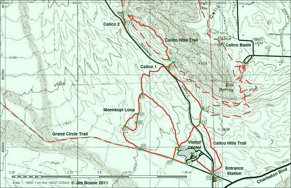
Note: Map based on USGS 7.5-minute topo map, which may have red grid lines and various numbers. North is at the top. Grid is UTM NAD27 CONUS. Roads are black (solid = paved; dashed = unpaved; width implies quality). Trails and routes are red (solid = main; dashed = adjacent or alternate). Washes, streams, and lakes are blue (solid = permanent; dashed = intermittent). National Conservation Areas (boundaries dash-dot green, fill light green) based on BLM data. Recent fires (boundaries solid red, fill crosshatch red) based on USGS data. Building areas (boundaries solid black, fill light green crosshatch) based on BLM data. Download waypoint coordinates from route description page.
Table 1. Hiking Coordinates and Distances based on GPS Record (NAD27; UTM Zone 11S). Download Hiking GPS Waypoints (*.gpx) file.
| Wpt. | Location | Easting | Northing | Elevation (ft) | Verified |
|---|---|---|---|---|---|
| 1 | Moenkopi-Grand Circle Trailhead | 641499 | 3999777 | 3,717 | GPS |
| 2 | Trail Junction | 641321 | 3999828 | 3,743 | GPS |
| 3 | Trail Junction | 641403 | 3999990 | 3,732 | GPS |
| 4 | Trail Junction | 640896 | 4000740 | 3,910 | GPS |
| 5 | Trail Junction | 640834 | 4000454 | 3,942 | GPS |
| 6 | Moenkopi Summit | 640815 | 4000336 | 3,956 | GPS |
| 7 | Trail Junction | 640653 | 4000285 | 3,858 | GPS |
| 8 | Trail Junction | 640865 | 3999968 | 3,780 | GPS |
| 9 | Entrance Station Trailhead | 641901 | 3999549 | 3,690 | GPS |
| 10 | Visitor Center Trail at road | 641868 | 3999621 | 3,691 | GPS |
| 11 | Visitor Center | 641580 | 3999907 | 3,784 | GPS |
| 12 | Calico Hills Trail at road | 641879 | 3999621 | 3,691 | GPS |
| 13 | Trail Junction | 641692 | 4000346 | 3,790 | GPS |
| 14 | Trail Junction | 641721 | 4000529 | 3,809 | GPS |
| 15 | Calico I | 641256 | 4001107 | 3,952 | GPS |
| 16 | Trail Junction | 641326 | 4001170 | 3,905 | GPS |
| 17 | Trail Junction | 641261 | 4001214 | 3,866 | GPS |
| 18 | Trail Junction | 640618 | 4001863 | 3,993 | GPS |
| 19 | Calico II | 640655 | 4001725 | 4,063 | GPS |
Happy Hiking! All distances, elevations, and other facts are approximate.
![]() ; Last updated 250416
; Last updated 250416
| Visitor Center Area Loops | Hiking Around Red Rock Canyon | Glossary | Copyright, Conditions, Disclaimer | Home |