Birding Around Las Vegas, Lake Mead Area
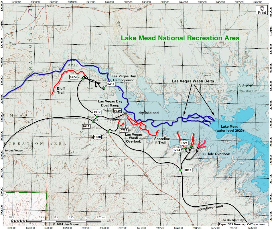
Note: Map based on USGS 7.5-minute topo map, which may have red grid lines and various numbers. North is at the top. Grid is UTM NAD27 CONUS. Roads are black (solid = paved; dashed = unpaved; width implies quality). Trails and routes are red (solid = main; dashed = adjacent or alternate). Washes, streams, and lakes are blue (solid = permanent; dashed = intermittent). National Park areas (boundaries dashed green, fill light green) based on NPS data. BLM areas (no color overlay) based on BLM data. Download waypoint coordinates from route description page.
Table 1. GPS Coordinates for Highway Locations (NAD27; UTM Zone 11S). Download Highway GPS Waypoints (*.gpx) file.
| Site | Location | UTM Easting | UTM Northing | Latitude (N) | Longitude (W) | Elevation (ft) |
|---|---|---|---|---|---|---|
| 1017 | Lakeshore Rd at 33 Hole Rd | 693999 | 3997679 | 36.10622 | 114.84482 | 1,316 |
| 1018 | Lakeshore Rd at Las Vegas Wash Rd | 691629 | 3998934 | 36.11799 | 114.87083 | 1,319 |
| 1388 | Lakeshore Rd at LV Wash Overlook Rd | 692034 | 3998675 | 36.11558 | 114.86639 | 1,297 |
| 1234 | Three-Island Overlook | 694130 | 3998261 | 36.11143 | 114.84322 | 1,234 |
| 0721 | 33 Hole Scenic Overlook | 694294 | 3998318 | 36.11191 | 114.84139 | 1,229 |
| 0722 | Las Vegas Bay Overlook | 692305 | 3998842 | 36.11703 | 114.86335 | 1,282 |
| 0720 | Las Vegas Bay Boat Ramp | 692499 | 3999163 | 36.11988 | 114.86111 | 1,157 |
| 1019 | Las Vegas Wash Rd at Camp Rd | 691725 | 3999050 | 36.11902 | 114.86973 | 1,280 |
| 0724 | Las Vegas Bay Camp entrance | 691336 | 4000071 | 36.12829 | 114.87381 | 1,259 |
| 0453 | Las Vegas Bay Camp overlook | 691894 | 3999850 | 36.12619 | 114.86766 | 1,260 |
Happy birding! All distances, elevations, and other facts are approximate.
![]() ; Last updated 240603
; Last updated 240603
| Las Vegas Wash | Birding Lake Mead | Birding Las Vegas | Copyright, Conditions, Disclaimer | Home |